Mostly I still know where my photographs have been captured a few weeks ago. But with five-year-old images I have much more problems... Unquestionably, a geotagger can really help to refresh an old man's memory ;).
The Nikon 1 AW1 and the D5300 have got an integrated GPS receiver. Unfortunately, Nikon's pro or semipro bodies do not have such a feature. With these cameras you have to go for an external solution. The D2, D3, D4, D200, D300, D700 and D800 models support a geotagger via the 10-pin remote control port.
|
|
It is a really small accessory! |
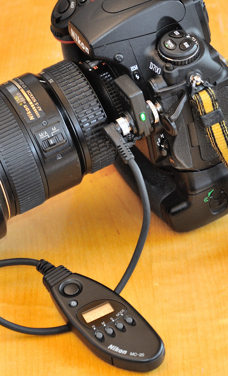
Nikon itself offers the GP-1A geotagger. It has to be mounted onto the hot shoe. A special cable connects it to the 10-pin port. Most of the third party geotaggers follow this mounting method. I don't like it. It makes a robust camera vulnerable, especially because of the cable. I would be afraid of catching on something.
An alternative is the di-GPS ECO PF1-M discussed here. It just has to be plugged into the 10-pin port. By design it only works in conjunction with the above-listed cameras while the Nikon GP-1A is also usable in combination with some consumer models via a USB cable.
|
|
|
|
|
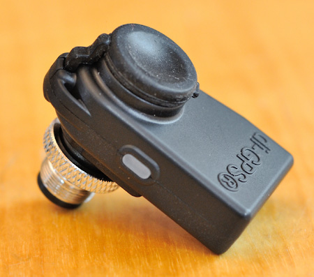
The di-GPS mounted on a D700. It makes it difficult to use the lens release button or the aperture ring. For some zoom lenses that is also true for the zoom ring. |
|
|
|
|
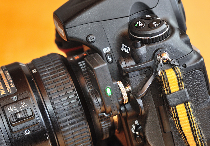
The di-GPS has a 10-pin port on the front. Thus, you can still use your remote control accessories! |
The di-GPS is a very small and inconspicuous GPS solution. It's too bad it is not suitable for being mounted all the time. I guess if it gets a serious hit, the unit itself or the camera's remote control port will be damaged. Therefore I am very careful with the left side of my D700...
Ergonomically the GPS receiver gets in the way of your left hand while changing the lens, setting the aperture of a manual focus lens or - in conjunction with some lenses - zooming or focussing respectively.
This is a plug and play accessory. There is just one thing you should do: in the GPS section of the camera menu set the "Auto meter off" parameter to "disabled". The di-GPS works great! It is fast and has a low power consumption. If you lose contact to the orbit the last position memory is very helpful.
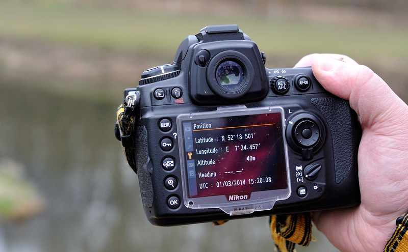
The precision of the di-GPS is very good, too. If you need an exact altitude value you should wait a moment without moving before you shoot. The GPS section of the camera menu offers to display your current position. That is very helpful to get a feeling for how the GPS unit works. Please note: the di-GPS - like many others - does not provide a heading information. It receives a UTC time signal from the satellites which can be used to set the camera clock.
|
|
Displaying the current position in the GPS section of the camera menu. |
If you are looking for a geotagger for your semipro or pro Nikon DSLR, the Dawntech di-GPS ECO PF1-M is a good choice. It's easy to mount and both the remote control port and the hot shoe remain available. As of March 2014 it costs about 175 € in Germany, which is 50 € less than the Nikon GP-1A. Although a mounted di-GPS in my opinion makes the camera less vulnerable than the usual hot shoe based solutions, you must treat your camera much more careful than without the di-GPS! Therefore I can not recommend the di-GPS as a solution for permanent use. I hope the next generation of Nikons pro or semipro DSLRs will have an integrated GPS receiver!
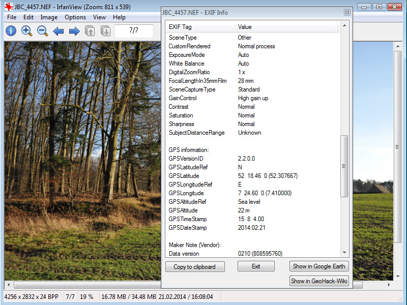
The current GPS data are recorded in the GPS section of the Exif data of your images. With an Exif viewer you can read this information.
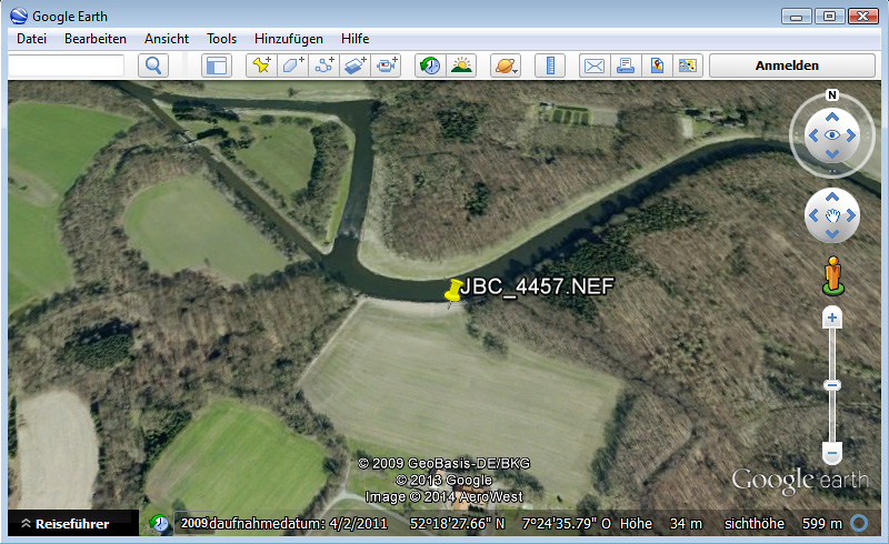
IrfanView - my preferred image viewer for both JPG and NEF/RAW files - has an integrated Exif viewer with a very useful "Show in Google Earth" button:
|
|
Other Exif viewers present the GPS data more nicely (for example: Opanda IExif 2). But IrfanView supports NEF/RAW files, offers the "Google Earth" button and I already use it for viewing and sorting out my images. |
|
|
The altitude measured by the di-GPS was 22m. In contrast, Google Earth reports 34m above sea level for this position. Google Earth is right here. If you want to get reasonable altitudes from the di-GPS, you must steady the camera for a moment. |